
Helping Sustain our Village Community + Working Creatively to Tackle the Challenge of Climate Change
The History of Ilmington - Chapter 5
The Open Fields
As has been shown in earlier chapters, Ilmington village was surrounded by its open fields from at least 1086-1781. To the present day farmer with his arable fields of a size in which two or three tractors can work at the same time, and the combine harvester can deliver grain to the drier in a few days, the difficulties of the farmer of the open fields must appear almost insuperable.
An Ecclesiastical Terrier, dated 1607, during the time of Augustin Walker, 1586-1631, is given in full below. It shows clear evidence of the four fields shown on Map 2, and includes many of the names given to their subdivisions, in some cases known as furlongs. The 'faire parsonedge house' stood much where the recently demolished National school stood at a later date, and the garden was in a part of what is now the churchyard. No trace of the dove house has been found. The close with the two small tenements recently erected, are what is now Glebe Cottage. Of the two tenements next to the street, one is at present being enlarged and restored, and lies at the south end of what was Crow Yard. The adjacent one has been demolished. A fifth, which at one time belonged to the rectory, but is not mentioned here, is Church Cottage.
This terrier is of particular interest, since it shows the enclosure of Southfield, which may have been before 1586, but cannot have been later than 1607. The house was not built until 1689.
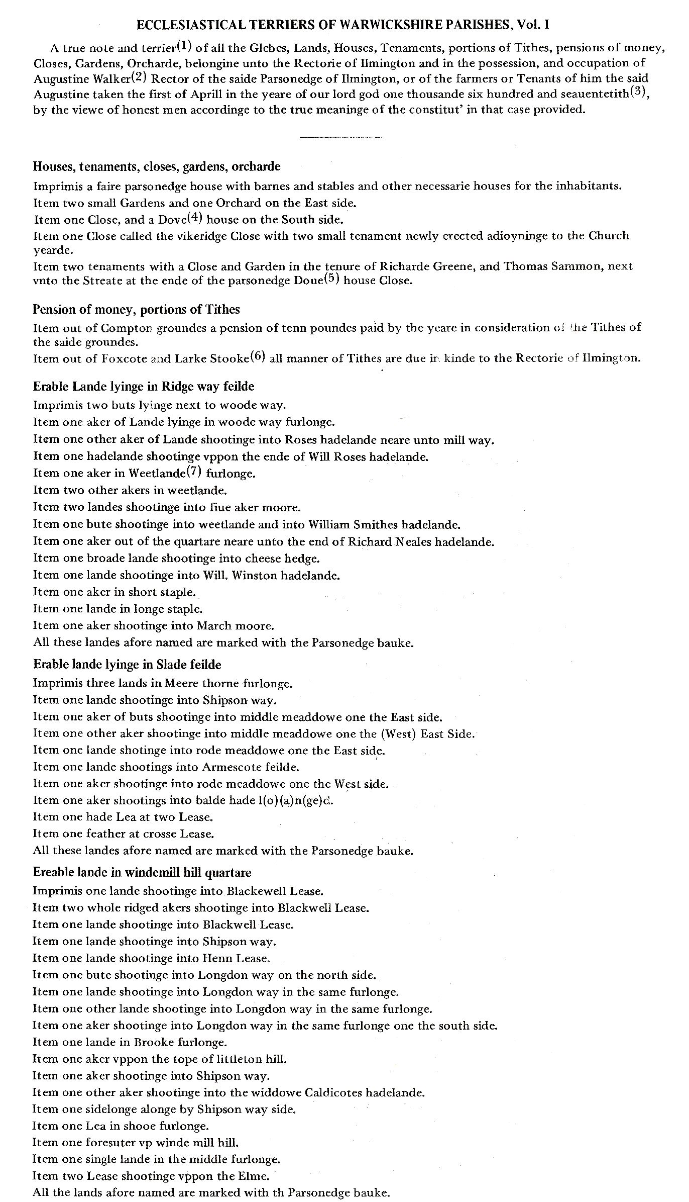
1. A terrier taken 5 July 1714 (DRO 72/65) is a copy of the above signed by Abraham Swanne, rector; John Hurlston and John Good, churchwardens; William Coldycott and John Bradly, overseers of the poor; William Rose, Samuel Smith, John Green, William Boulton, Richard Sansom, and William Harbridge. Michael Wells makes a mark. In this terrier all tenements and holdings mentioned are said to be 'formerly' in the tenure of the occupants named below, and to descriptions such as 'Will Roses' hadland' is added in 1714 'formerly so called'.
2. Augustine Walker, M.A. (see Foster), was instituted to the rectory on 22 November 1586 (Dugdale, i. 630) and remained rector until he died in November 1631 (J.H. Bloom, quoting the parish register, Birmingham Ref. Lb. MSA 95938, p.219).
3. This must be 1607, not 1670.
4. The dovehouse is omitted in 1714.
5. Parsonage house close, 1714.
6. And alsoe out of Lark Stoake after the expiracion of a Lease 1714.
7. Spelt variously Wet—, wett—, weett—, land, 1714.
8. Whettington, 1714.
9. att, 1714.
10. Winstons, 1714.
11. Lease on pishill, 1714.
12. The farmers of the Rectory heretofore & the present Rector, 1714.
13. In 1714 is added: Item one sidelong upon nether Littleton Hill. Item one acre of Butts under Bruton hedge.
14. A word has been deleted and cannot be read.

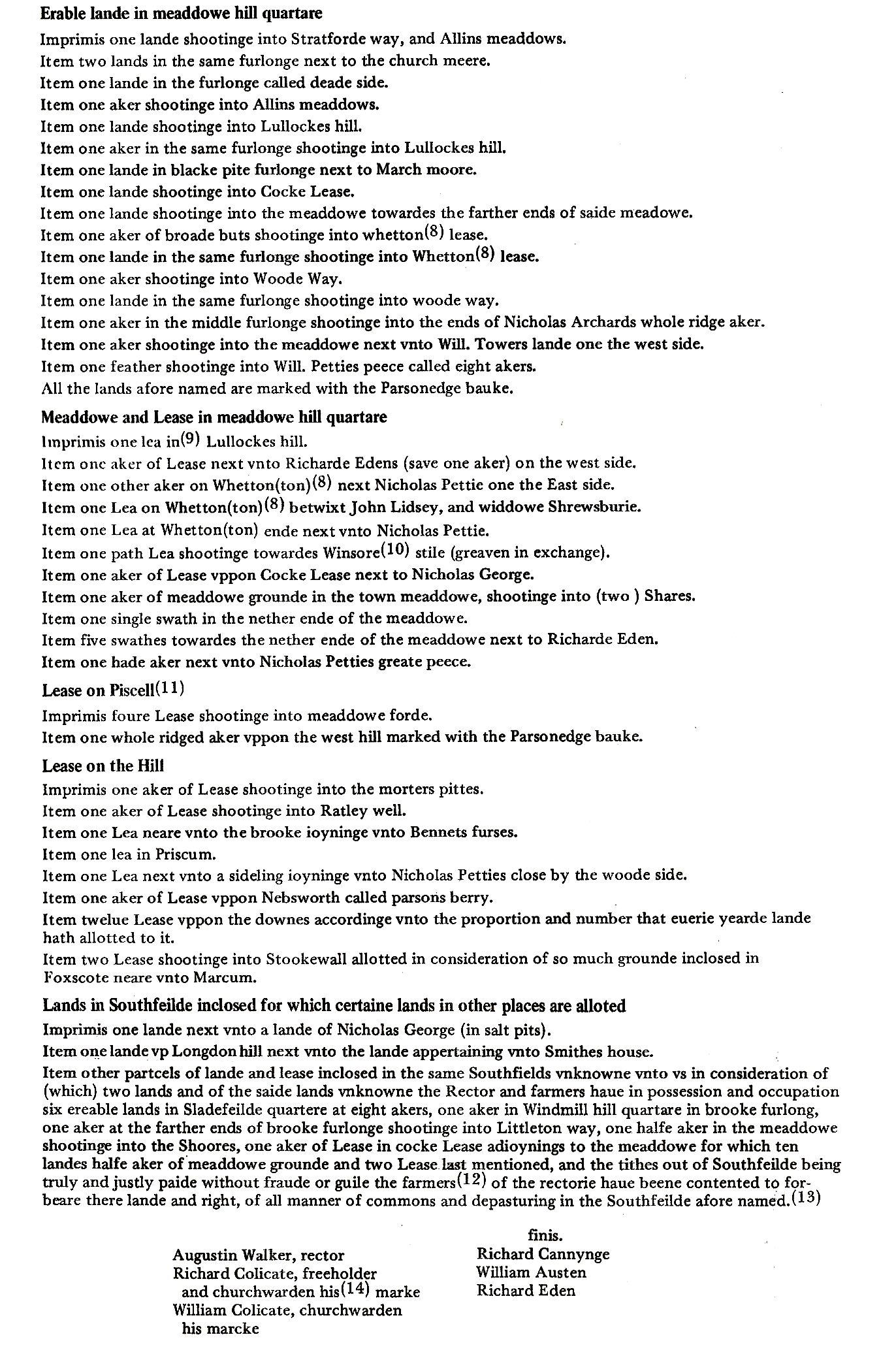
A list of strips of a two yardland farm extracted from a document concerning three farms.
A portion of the map showing the strips of which the list has been given.
These strips are marked K

The Homestall of the farm. Now known as Folly farm
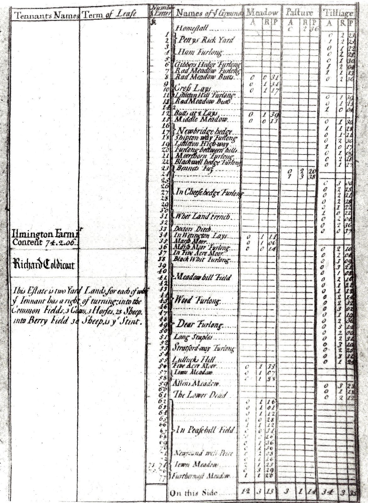
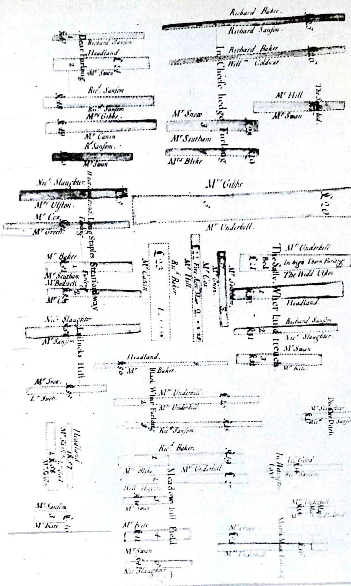
A further example of the distribution of strips in the fields, and how they were shown when a farm was being leased has been found for a two yard land farm leased to Richard Coldicott in 1700, by Bowater Vernon (1). In this case the list of strips has been given in full, but only enough of the map is included to show how the strips were identified in the field. On this map there is a minute drawing of the house and homestall which has been enlarged. This identifies the house as Folly Farm in Back Street. Though architect's plans of the present house have been examined it is still impossible to say exactly what it was like when it was the house of a two yard land farmer in 1700. It must certainly have been included in the Hearth Tax of 1674 and had not less than two hearths but may well have had three. Half the roof of this house was repaired some time ago and it was estimated that the Cotswold stone tiles of this half weighed 25 tons. On the outside of the house projects the curve of the baking oven. It is one of the few of this kind to be found in Ilmington.
This lease shows clearly that a yardland carried with it common land for grazing and meadow land for hay. In this case the farm of just over 74 acres included 3 acres of grazing land and 12 acres of meadow for hay. The size of the farm determined the number of animals which might be kept and in this case it was 6 cows, 6 horses and 60 sheep. It must be remembered that a certain proportion of the arable would be fallow each year. This fallow land provided between certain dates useful grazing for animals. The field which had been fallow was the one sown with winter wheat for the following year. Some of the huge fields of the present day, now some of the enclosure hedges have been removed, may be not unlike the winter wheat field of pre-enclosure times, though the crop would be interrupted by the divisions between the strips.
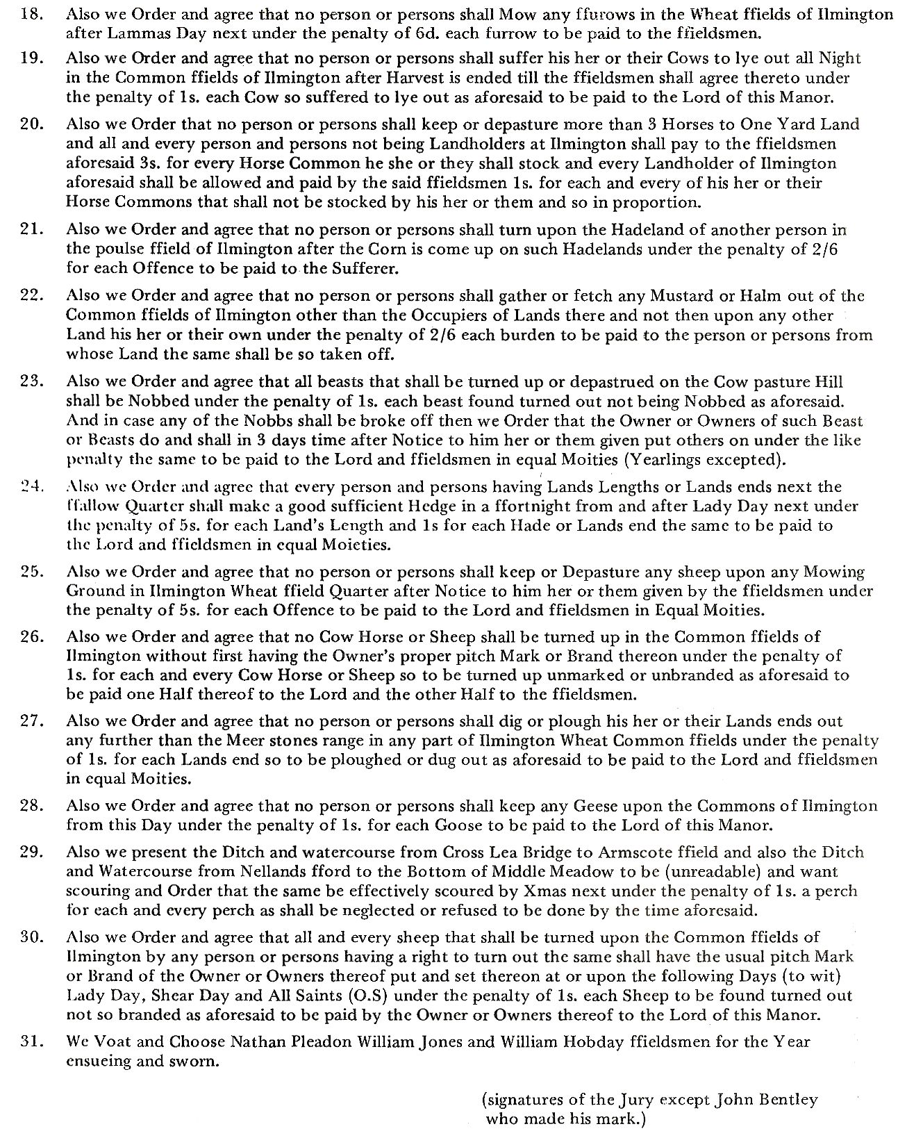
Farming operations were governed by the Court Baron. Records of this have been found only for the second half of the 18th century. Those for 1756 (2), 1763 (3), 1767 (4), 1769 (5) and 1775 (6) have been examined and they have been collected from Birmingham, Stratford, Warwick and Gloucester. That for 1769 from Gloucester is much the most informative and is given below.
The Court Baron of Francis Canning Esq. Lord of the Manor of Ilmington holden at the place accustomed on Tuesday the 3rd day of October in the 9th year of the Reign of King George the Third and in the year of our Lord 1769 beford Thomas Snow Gent. Steward there.


* - No explanation of the meaning of this rule has yet been found.
Crops other than wheat for which there is evidence from wills and inventories were barley, peas, beans, oats, vetches and hay. From the Court Baron it seems that mustard was grown.
The number of animals allowed for each yard land has already been given. Before 1698 this number had been larger, 4 horses, 4 cows and 40 sheep. Since the pasturing of geese was forbidden in 1769 it would seem that these had been provided for at an earlier date. Though the rules must have been very limiting it seems clear that renting commons for those who wished to keep extra animals was possible, and maybe on a small scale even for those without land. Map 3 shows the distribution of arable, meadow and commons of pre-enclosure Ilmington. Not all the land showing ridge and furrow was necessarily arable at this time, though it must have been either before that time or more recently.
Much of the history of the land lies hidden in the field names, if they can be correctly interpreted. Ilmington's land has been occupied for so long that the language of its people has passed through many changes, and these changes have of course been reflected in the names of the fields; yet this is a continuous process, and is an example of the persistence of oral tradition, seen again in the Mummers' play given at the end of this book. As with the Mummers' play, so with the field names, original meanings have often been lost and can be recovered with certainty only by a series of documents showing changes of spelling on the rare occasions when the names were written down. Such a series does not exist for Ilmington, and if it did their interpretation would involve much linguistic ability not possessed by the authors of this book. However, the changes which have occurred here are at least likely to be similar to those which have taken place elsewhere, and with the help of 'English Field Names' by John Field published by David and Charles in 1972, the following interpretations are offered. Only one name in this book is actually assigned to Ilmington. It is Brook Furlong, said to date from the time of Henry III (who came to the throne in 1216), but the document for this is now lost. The highly suggestive interpretation of Berry Orchard has already been given in connection with the manor.
Many new names must have been introduced after the Enclosure of 1781, when even the meaning of 'field' took on the new connotation of an enclosed area of perhaps ten acres or less, as distinct from its earlier meaning of a particular group of strips totalling in all perhaps nearly a quarter of the arable land of the whole community. These field names were recorded by the school under the auspices of the County Authority in 1934 and are shown on Map 5 (this map is given at the end of the Chapter 9 because it shows the field pattern resulting from enclosure). Certain general terms, many still in use today, had specific meaning. These are as follows:-
A furlong - a group of strips all the same length.
A hadeland or headland - the land needed for the plough team to turn.
It was ploughed or dug when the rest of the ploughing had been completed.
Butts - the irregular shaped areas at the end of some furlongs.
Leys or lease - areas of grassland.
Meadow - grassland reserved in season for hay.
Ground - grassland.
Well - a spring.
The names for which an attempt at interpretation follows have been taken from the Enclosure Award, the Ecclesiastical Terrier and the lease of Folly Farm. Not all can be found on maps 3 and 4, which have been reconstructed from the partial map accompanying the enclosure award and an aerial photograph of 1946. The completed map which must have been drawn for the Enclosure has been lost.

Map 3 - Based upon the Ordnance Survey Map with the sanction of the Controller of Her Majesty's Stationery Office,
Crown Copyright reserved
Names recording the people who once held the land:-
Bennett's Furze, Spilsbury's piece, Smith's piece, Parson's Wythies, Clarkson's piece, Petty's close and rickyard, Gilbert's hedge, Danbury's hedge, Allen's meadow.
Of these names, only Gilbert has not been found in other documents.
Names indicating boundaries:-
Markham or Marcum - probably old English 'mearc'.
Meerthorn furlong.
Hoarstone - this is a boundary mentioned in the Saxon charter for Tredington of 757 A.D.
Church meer.
Names showing the size of the area:-
Five acre moor, Nine lands furlong, Eight leys furlong and Eight akers, which may be the same as Eight leys. Nellands may mean Nine lands or a mound, and both interpretations could fit.
Other names reflect some characteristic of the ground. Any including 'moor' mean barren wasteland from the Old English 'mör':-
Holwell - spring in a hollow.
Rod meadow - Rod may mean reeds and therefore damp ground.
Chillcroft - croft by a cold spring.
Slade - valley or low lying marshy ground.
Black pitt - dark soil - Old English blaec.
Featherbed - crumbly soil (said to be a 'fanciful' name).
Stonehill - either the site from which stone was dug, or from shallow and therefore stoney soil. Either would apply.
Names indicating crops:-
Ballands - bean ground.
Pisshill - pease ground.
Wheatland trench - perhaps good wheat land, but it has several spellings.
Fernhill
Woodway - this may have its obvious meaning, but a certain woodland at Stratford was in 1339 'Wodland' and referred to the growing of woad.
Some refer to other uses:-
Morters pits - land from which lime was dug for mortar.
Little, Middle and Far Walk hill - this may refer to the fulling of cloth, and for this blue clay was used. It certainly underlies some of the ground, but whether this is so in the region of these fields is not known. 'Walk' could also mean a path cut through a wood, it may also mean a sheep walk.
Drove leys and Driftway probably indicate proximity to tracks along which cattle were driven, and may refer to paths used by drovers bringing cattle and sheep from Wales and even Ireland to London. This practice continued from the 13th century until railway transport was available.
Strait is said to mean proximity to a Roman track.
Some names are connected with animals:-
Deer furlong.
Cock leys - this may refer to woodcock or to the breeding of game cocks.
Swinesty - this has a variety of spellings. It may mean the ground for pigs.
Long and Short staples. This is a very tantalising name. The Merchants of the Staple controlled the wool trade from the 12th century, and Campden is one of the finest of the 'wool churches', but the name Staple occurs as a surname in at least one Ilmington document. The name could also mean post or pillar, indicating a boundary.
Some names suggest outlying parts:-
Furthermost meadow.
Far bottom fuzground.
California.
New York farm (now York farm).
and lastly Galley hook or Galley oak - probably the site of the gallows when the lord of the manor had the right to hang offenders.
Even with the uncertainties attendant on such an amateurish attempt at interpretation of this selection of names, and it is not exhaustive, some idea of the changes in the use of the land through the ages can be glimpsed.
The illustration at the end of this chapter shows the introduction of dibbling corn into the ground in about 1600, an improvement on broadcast sowing. The method was still used in Ilmington in the late 19th century. This comes from 'The Farmers' Tools'. A history of British Farm Implements AD 1500-1900.
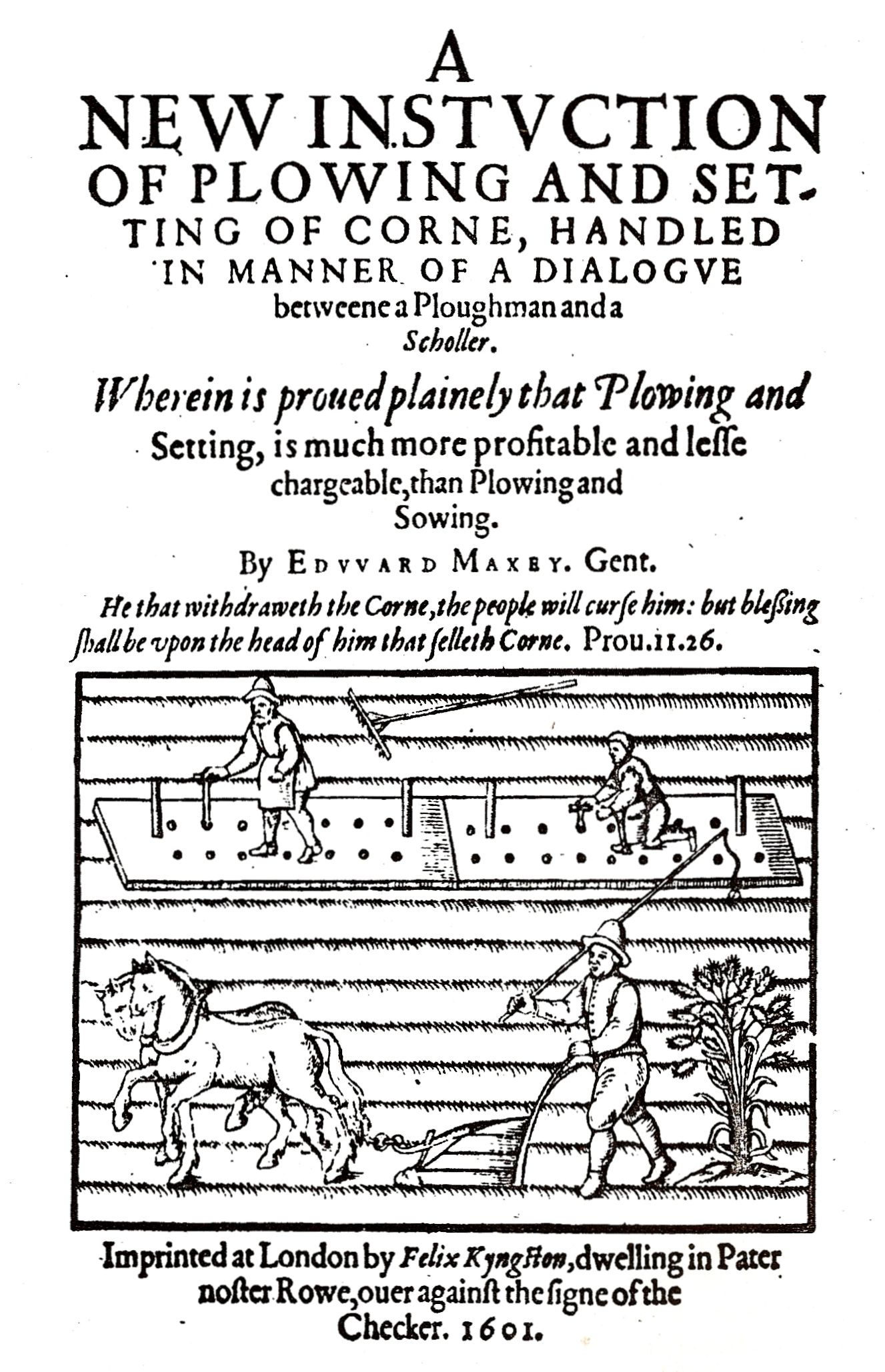
Setting board. Title page of Edward Maxey. New Instruction of Plowing. 1601.
By kind permission of the British Museum
-
Worcester Record Office F 970.5.7 BA 1101/1.
-
Shakespeare Birthplace Trust ER 24/16/1-2.
-
Birmingham Local Studies Library No. 365072.
-
Gloucester City Libraries. Sir Thomas Phillips (no. 15452).
-
Gloucester City Libraries. Sir Thomas Phillips (no. 15452).
-
Shakespeare Birthplace Trust ER 24/16/3.